 The National Oceanic and Atmospheric Administration is currently working on modernizing and updating probable maximum precipitation (PMP) and precipitation frequency estimates to account for future climate variability. These two extreme precipitation datasets for decades have been referenced in many engineering design standards and floodplain regulations, and engineers and other practitioners use those standards and regulations to make local decisions.
NOAA initiated the development of the National Precipitation Frequency Atlas of the United States (“NOAA Atlas 15”), the latest update to the precipitation frequency data presented in Atlas 14. Recently, they released the NOAA Atlas 15 Pilot, a first look at the structure of the NOAA Atlas 15 dataset, and are currently collecting early feedback on development framework and web dissemination strategies. NOAA is also working on the scientific approach to modernizing PMP estimates, and is engaging the stakeholders to share the results of the consensus study report published by National Academies of Sciences, Engineering, and Medicine.
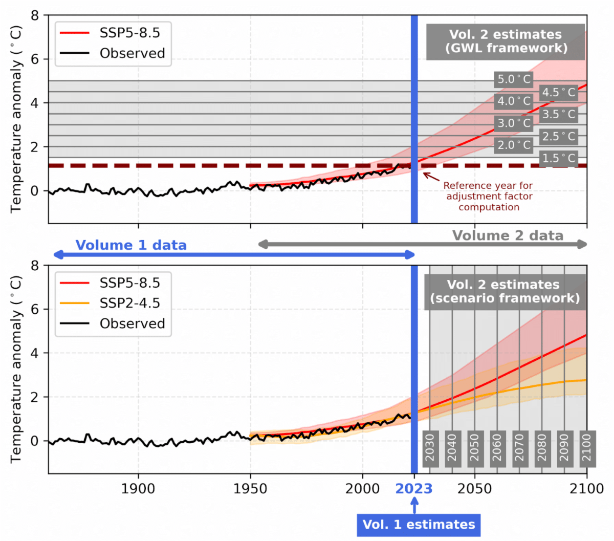
NOAA Atlas 15 pilot contains two volumes and this data will be refined through 2026 and 2027, when NOAA Atlas 15 is fully published. Volume 1 provides precipitation frequency estimates for 2023 based on historical trends in observations, while Volume 2 provides a range of possible future precipitation frequency estimates within two distinct frameworks: global warming level (top figure) and emission scenarios (bottom figure). Atlas 15 Pilot pages are available for review here.
The FEMA Technical Mapping Advisory Council (TMAC) is a federal advisory council established to review and make recommendations to FEMA on matters related to the national flood mapping program. Recently TMAC developed recommendations related to future conditions flood mapping. In addition to precipitation estimates, TMAC included recommendations related to future conditions associated with the allowable increases associated with floodway surcharge and increased development in the watershed. ASFPM has recently developed an outreach packet to improve community understanding of floodway surcharge and provide options to minimize the impacts on existing development.
Presenters:
- Alan Lulloff, PE, CFM - ASFPM Flood Science Center
- Doug Bellomo, P.E., AECOM
- Jeff Sparrow, P.E., CFM, Moffat & Nichol
- Sandra Pavlovic, P.E., MBA, M.S., NOAA
- Kelly Mahoney, PhD, NOAA
Agenda:
- Webinar Logistics
- Introduction
- TMAC Recommendations - Future Conditions
- NOAA Atlas 15 Pilot
- Probable Maximum Precipitation
- Questions/discussion
Slides: Future Conditions Flood Mapping
Recording: Future Conditions Flood Mapping
Note: Viewing the recording of this webinar is not eligible for CECs.
 Download Calendar Event
 Back to Calendar